Preliminary fieldwork results
Preliminary fieldwork results
Sidh Losa Mendiratta & Fernando Velho
Sidh Losa Mendiratta & Fernando Velho
Project: "Old Goa - Searching for the
lost city."
Na continuação do post de 28 de Janeiro último em que davamos conta de uma bolsa de estudo atribuída a Sidh Losa Mendiratta, no âmbito do projeto Old Goa - searching for the lost city http://bolseiros.foriente.pt/2019/01/preparing-fieldwork-sidh-losa.html,
Damos agora a conhecer os resultados preliminares do projeto.
Mirroring the Portuguese empire's
wanes and misfortunes, the city of Old Goa - once the Christian missionary
capital of Asia - had a slow and agonizing decline, being finally abandoned in
the 1830s, when its convents were closed down. Throughout the 19th century, Old
Goa was systematically dismantled, and its building materials reused in the new
capital of the Estado da Índia, Pangim,
just a few kilometers away. The project "Old Goa - searching for the lost city",
coordinated by architects Sidh Losa Mendiratta and Fernando Velho, aims at
creating a digital archaeological map of Old Goa, connectable to
heritage-focused databases.
 |
| Sidh Mendiratta and Fernando Velho
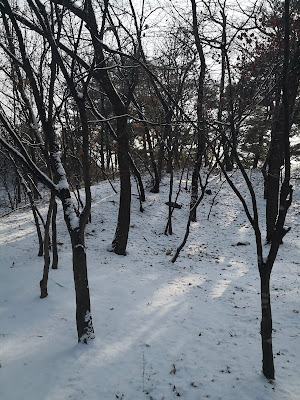
Ruins of N. Sra. do Carmo (© Claúdia Duarte 2019)
|
Between the 6th and the 27th of February
2019, the project’s coordinators conducted a series of archaeological
prospections in Old Goa and also in its surrounding territory. Besides this
activity, there were two topographical surveying operations, one in Bom Jesus
church and professed house, and the other in the area of the church of Nossa
Senhora do Carmo.
The archaeological prospection
focused on four areas of Old Goa, as can be seen in the map below. Area I
corresponds to the old convent of São Domingos, built by the Dominican order
form the 1550s onwards, and abandoned in 1835. Area II corresponds to the area
occupied by the ruins of the church of Nossa Senhora do Carmo, and also the
location of the chapel of Santo Amaro. Area III is the Monte Santo hillock,
with various religious structures. Area IV is corresponds to the location of
the church of Nossa Senhora da Luz.
 |
| Map of Old Goa with prospection areas |
Area I: One of the most grandiose
buildings of Old Goa was the Dominican church and convent of São Domingo, built
in the 1550s and 1560s. With its two cloisters and three-nave church, the
structure dominated one of the eastern hillocks of Old Goa. Abandoned in 1835,
it was later systematically demolished and its building materials reused
elsewhere. Preliminary assessments allowed the coordinators to identify the
Dominican church's chancel area, with the location of various ornamental basal
stones marking the area. It was also possible to establish the route that
conveyed water from a spring in the hillock to a public fountain in the road
leading to Daugim. Furthermore, it was possible to tentatively locate the
fountain of São João Baptista, one of the preferred sources of water for the
inhabitants of Old Goa, and located in the eastern area of the Dominican
property.
 |
Carved stone in the ruins of S. Domingos (© Sidh Mendiratta
2019)
|
Area II: Upon another hillock,
just south of the Dominican convent, was the church and convent of Nossa
Senhora do Carmo, built by the Carmelite missionaries in the 1630s and 1640s. This
unique building introduced many novel architecture features in Old Goa, with
strong influences from the Italian peninsula. The church was reached via a
monumental staircase, and terraces leading down the slope surrounded the
conventual structures. The church was built very close to the chapel of Santo
Amaro, a building not connected to the Carmelites, and probably built in the
1560s. The location of this chapel is incorrectly given in the 1910 Obras
Públicas map of Old Goa, and therefore, the coordinators conducted a
prospection to find its precise location. Although no ruins were visible, some
rubble and the landscape features of the terrain allow us to tentatively mark
the chapel's location, pending an in-depth archaeological study. New features
visible on the site of Nossa Senhora do Carmo, following a vegetation
clearance, led to the coordinators conducting a geo-referenced topographical
survey to complete the information already recorded on site.
 |
Tombstone recently located in the ruins of N. Sra. do Carmo
(© Sidh Mendiratta 2019)
|
Area III: Recent excavations by
the Archaeological Survey of India in the area of the Augustinian convent of
Nossa Senhora da Graça have exposed conventual structures here to unstudied.
This area, which connected to the adjoining college of Nossa Senhora do Pópulo,
will allow us to better understand the whole monumental Augustinian group of
buildings, which once dominated the Monte Santo. Archaeological prospection was
also conducted in the are of the Jesuit college of São Roque, where a few
fragmented decorated stones were located.
Area IV: The parish church of
Nossa Senhora da Luz, in the southern central area of Old Goa, was the first
church built specifically for the converted local population of Goa, allowing
them to have a vocal say in church matters. Following archaeological
prospection on the site, unfortunately, it was visible that a crematorium of
recent construction now occupies much of the area where this church used to
stand.
A few sites around Old Goa were
subject to archaeological prospection or study, including the chapel of São João
Baptista in Siridão, the monumental fountain of Curca belonging to the
village's Dominican retreat, and the retreat of Santa Rosália founded by the
Jesuits.

Comentários
Enviar um comentário